
NOAA/ESRL Including Wildfire Smoke Particles and Chemical Data Assimilation in High Resolution Real-Time Forecasts
![]()
The 2009 NOAA Science Advisory Board as well as the 2012 NOAA/USFS research MOU highlighted the need for coupled wildfire-meteorological forecast models to better understand the impact wildfires have on the local fire suppression support, regional air quality and aviation interests. The work at NOAA/ESRL of including wildfire smoke into the real time forecasts, as well as its feedbacks upon the weather, addresses this challenge. In addition, advances in chemical data assimilation in real time forecasts relate to both NOAA’s climate and weather goals by enhancing the understanding of radiatively important fine-particle aerosols as well as improving the air quality forecast models.
An experimental model forecast using the High Resolution Rapid Refresh has been configured to run in real time while including fine and large particle (PM 2.5, PM 10) emissions as well as particle-weather interactions. This model configuration, using 3-km horizontal resolution, is based upon the WRF/chem model (Grell et al., 2005) and uses the GOCART aerosol scheme and initializes particulate emissions from wildfires using WF-ABBA and MODIS satellite data (Grell et al., 2011). In addition, The initial particles for the forecast are generated using previous forecast data along with chemical data assimilation via the Gridpoint Statistical Interpolation (GSI) methodology (Pagowski et al., 2010). During the chemical data assimilation segment, observations from over 380 cities across the lower 48 United States are used to refine the previous 6-hour three-dimensional weather/particle forecast fields. This is one of the first NOAA models to include chemical data assimilation in real time forecasts and so far it has demonstrated a significant improvement in fine particulate matter forecasts.
During one of the real time forecasts on 26 May 2012, a narrow plume of fine particle smoke was transported by the strong winds from the Whitewater-Baldy fires in New Mexico north-northeastward over Colorado where it mixed down to the surface. Satellite data and observational reports revealed that a hazy, brown cloud of fine particles plagued the Colorado Front Range during the first part of the 2012 Memorial Day weekend. The real-time HRRR-Chem numerical forecast produced at NOAA/ESRL/GSD did remarkably well at capturing the narrow plume of fine particles from the New Mexico fires and its impact on Colorado regional air quality due to the inclusion of wildfire smoke emissions and chemical data assimilation.
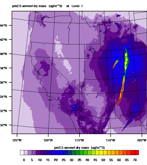
The above figure shows the HRRR-Chem surface fine particulate matter (pm2.5) at 00 UTC analysis on 27 May 2012. The HRRR-Chem model did well at capturing the narrow plume of particles eminating from the Whitewater-Baldy fires in New Mexico and their northward transport to the Colorado Front Range. Several smaller fires show-up in the image as shorter particulate plumes in Utah, Wyoming, Colorado and Mexico. The HRRR-Chem model also does a reasonable job at representing the background particulate concentration away from the smoke plume.
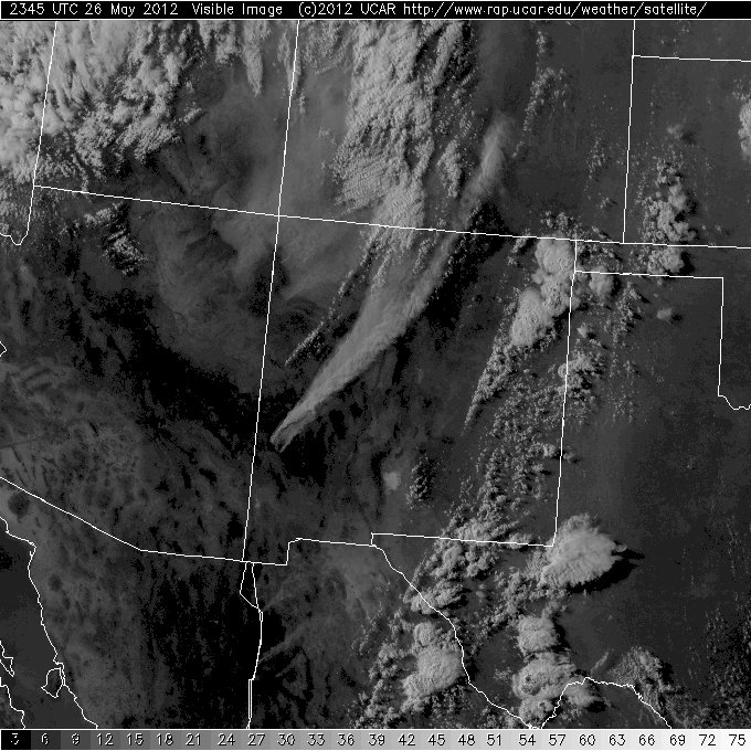
The GOES-13 visible satellite image showing the clouds, dust and wildfire smoke at 2345 UTC analysis on 26 May 2012. The smoke plume from the Whitewater-Baldy fires orginates in the west central mountains of New Mexico and follows a curved path just west of Albuquerque and northward to the Front Range of Colorado. The surface level fine particulate matter in the Denver to Fort Collins corridor shows up as a grey north-south band extending from the end of the upper-level plume and is located just to the east of the darker appearing mountains and overlying nearly white convective clouds that are more prominent over the western third of Colorado.
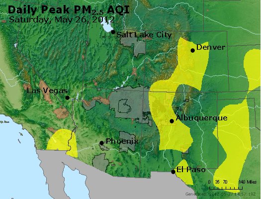
Observed peak file particle air quality index reported by US EPA AIRNOW observing network for the desert southwest region on 26 May 2012. Regions shaded by the yellow color are reported to have had a moderate air quality index indicative of daily averaged PM 2.5 concentrations at or above 15.5 micrograms per cubic meter. People with allergy or respitory problems living in locations having air quality in the moderate category are at a higher risk of having health related issues during these days.
![]()
Contributing Scientists NOAA/ESRL/GSD | Contributing Scientists NOAA/ESRL/CSD |