 Figure 2
William R. Moninger (1), Richard D. Mamrosh (2), Patricia M. Pauley (3)
ABSTRACT
Commercial aircraft now provide over 130,000 meteorological observations per day, including temperature, winds, and in some cases humidity, vertical wind gust, or eddy dissipation rate (turbulence). The temperature and wind data are used in most operational numerical weather prediction models at the National Centers for Environmental Prediction (NCEP) and at other centers worldwide. At non-synoptic times, these data are often the primary source of upper air information over the U.S. Even at synoptic times, these data are critical in depicting the atmosphere along oceanic air routes.
A web site (http://acweb.fsl.noaa.gov/) has been developed that gives selected users access to these data. Because the data are proprietary to the airlines, real-time access is restricted to entities such as government agencies and nonprofit research institutions (although sample past data are available to all). Data can be displayed in a variety of ways and can be downloaded for local processing.
We describe these data, and show examples of how they have been useful in weather forecasting and numerical weather prediction.
1. Introduction
Automated weather reports from commercial aircraft have been an important data source for numerical weather prediction (NWP) models for more than a decade, and have improved the forecasts from these models. More recently, direct access to these reports has become available to government weather forecasters and other researchers through a web site operated by NOAA's Forecast Systems Laboratory (FSL). Direct access to these data has resulted in better quality control of the data, and more timely and accurate forecasts.
We provide an overview of the kinds of aircraft data that are currently available, a brief history and overview of FSL's web site and other data distribution mechanisms, a look at the use of the data in models, and examples of the use of these data in research and operational forecasting.
2. Data Sources
a. Overview
 Figure 1.
Routine meteorological observations from aircraft have been taken since the days of World War I. In 1919, the Weather Bureau began paying pilots of piston-engine aircraft to fly with "aerometeorographs" strapped to the aircraft wing struts (Hughes and Gedzelman 1995) (Figure 1). The observations were recorded on a cylindrical chart that was retrieved after the aircraft landed; the temperatures, pressures, and relative humidities were then read from the chart (Harrison 1935) and disseminated as "APOBs"-airplane observations (Huschke 1959, p. 37). Pilots were required to reach an altitude of at least 13500 ft in order to be paid and were given a 10% bonus for each 1000 ft above that. At these altitudes, pilots sometimes blacked out from lack of oxygen making this a very dangerous enterprise-12 pilots were killed between 1931 and 1938 (Hughes and Gedzelman, 1995). By 1937, the U. S. Government funded 30 regularly scheduled civilian and military aircraft "soundings" per day in the U.S., but by 1940, these were replaced by soundings made by the newly developed radiosonde (NOAA/NWS 2001). In fact, an important step in validating the radiosonde was a comparison with collocated aircraft soundings (Diamond et al. 1938).
However, just as commercial aviation has become routine, so have aircraft meteorological observations. Voice pilot reports, suitably encoded, have been used in Numerical Weather Prediction (NWP) models for nearly four decades. Automated aircraft reports first became available in 1979 (Sparkman et al. 1981; Giraytys et al. 1981; Lord et al. 1984) and have increased dramatically in the 1990's.
Figure 2 shows a time history of both manual and automated wind reports used in NWP models from 1960 through 1999, from the National Centers for Environmental Prediction (NCEP)/National Center for Atmospheric Research (NCAR) reanalysis project (Kalnay et al. 1996). Although not precisely equivalent to the number or reports available in real time, these numbers do portray the general trends seen in operational reports.Figure 3 shows currently available automated data worldwide for 27 March 2002. More than 130,000 point observations of winds and temperature are now available daily.
Automated meteorological reports from aircraft are generically called AMDAR (Aircraft Meteorological Data Relay) reports. In the United States, however, these data are generally referred to as ACARS data. (ACARS stands for Aircraft Communication Addressing and Reporting System, a communication system operated for the airlines by Aeronautical Radio Inc. [ARINC] that reports a number of aircraft parameters such as passenger loading, and dispatch information along with weather information. We use the term ACARS to refer to only the weather information from U. S. carriers.) The U. S. data are also sometimes referred to as MDCRS (Meteorological Data Collection and Reporting System). MDCRS (Petersen et al. 1992) is a database containing ACARS data and a distribution system that feeds the data from ARINC, where the database resides, to NCEP, where the data are used in NCEP's operational models and placed on the GTS (Global Telecommunications System) for distribution to government NWP centers worldwide.
These reports generally include temperature and horizontal wind. In addition, some provide measurements of dewpoint and turbulence (see section 2.c.)
Six domestic airlines currently provide ACARS data: American, Delta, Federal Express (FedEx), Northwest, United (UAL), and United Parcel Service (UPS). In Figure 3, ACARS coverage, comprising more than 102,000 observations, is shown in red.
Outside of the U. S., AMDAR systems are established on a national or regional basis. Communications for these systems are generally handled by SITA (http://www.sita.aero/) and other smaller providers, rather than ARINC. In 1986, the Australian program became the first operational AMDAR system (Sprinkle 1999). Development was led by the Australian Bureau of Meteorology in conjunction with the airlines, with the Bureau paying for the observations and controlling the type of observations, the frequency of reports, the region within which reports are made, data quality, and data distribution, with the latter free to all users globally (Stickland, personal communication). This model was later developed by all new AMDAR systems, with the exception of the U.S., where the airlines pay for and retain control over the data.
AMDAR participating countries (airlines) currently include: France (Air France), the United Kingdom (British Airways), the Netherlands (KLM), Germany (Lufthansa), Sweden (SAS), Australia (Qantas), New Zealand (Air New Zealand), and South Africa (South African Airways). In Figure 3, AMDAR coverage, comprising more than 28,000 observations, is shown in blue.
b. Temporal/spatial coverage and robustness
A recent study of data coverage (Jamison and Moninger, 2002), that focused on data over the contiguous United States, revealed the following:
The bulk of near-surface data is provided by the package carriers FedEx and UPS because they use a data format that provides high-vertical-resolution data at low levels.
Most data are gathered at flight levels (25000- 45000 ft) (Figure 4) where they are distributed fairly uniformly over the CONUS.
 Figure 4
Below about 25,000 ft, data are concentrated near major hubs (Figure 5).
 Figure 5
Patterns over the rest of the world are similar. Package carriers do not provide as large a fraction of data, but some airlines, such as Lufthansa, do provide high-vertical-resolution data at low levels.
Unlike many other sources of meteorological data such as satellites, radiosondes, and automated surface stations, aircraft can be directly affected by inclement weather-when major storms occur, aircraft often do not fly, as most air travelers know all too well. One of us looked at two major storms in order to assess the extent to which these storms disrupted aircraft data over the contiguous U.S. The storms studied were Hurricane Floyd, which occurred during September 1999 (Moninger 1999), and a major East Coast blizzard which occurred in January 2000 (Moninger 2000). These studies concluded that extended periods of poor weather can indeed decrease the number of aircraft data, both in the region of inclement weather and elsewhere. The East Coast Blizzard, for instance, caused an 8% decrease in the nationwide aircraft soundings (ascents and descents) and affected regions, such as Denver (an 8% decrease), far removed from the blizzard. This is because a cancelled flight results in missed soundings at both the origin and destination airports, and because grounded aircraft disrupt air traffic flow in general.
Ice and snow seem to be the most troublesome weather. Low visibility alone does not affect landings when airport, crew, and equipment are certified for low-visibility approaches, though it may decrease throughput at busy airports (Randy Baker, personal communication). Recovery from inclement weather events occurs relatively quickly at major hubs, but may take several days at regional airports. Radiosondes, by contrast, are more robust against inclement weather. Most missed radiosondes are not caused by weather, but by staffing or equipment problems (NOAA, 2000). Thus missing radiosondes are likely to be random in space and time. Nonetheless, aircraft data are the only in situ source of upper-air data at non-synoptic times, and therefore are highly valuable.
c. Turbulence and water vapor
In addition to temperature and winds, various measures of turbulence are also computed on some aircraft fleets. Derived Equivalent Vertical Gust (DEVG) values have been included in all Australian AMDAR reports since their inception in 1985 (WMO 1999), and in most European AMDAR reports (after conversion to turbulence categories) (J. Stickland, personal communication). A second measure in use on some aircraft is vertical acceleration, reported in multiples of the acceleration of gravity. These data have been found to be inaccurate for nonzero values of vertical acceleration, but the data may be of value in measuring of the absence of turbulence-critically necessary in calibrating turbulence forecasting models. A third measure of turbulence is the NCAR-developed Eddy Dissipation Rate (EDR) algorithm. EDR is a "state-of-the-atmosphere" rather than a "state-of-the-aircraft" measure and so is independent of aircraft type and thus can be used in NWP models (Cornman et al. 1995). Stickland (1998) compared DEVG and EDR and recommended the use of EDR. As of April 2002 AMDAR data include approximately 75 aircraft that report vertical gust, and ACARS data include 75 aircraft reporting EDR, and 90 reporting (incorrect) vertical acceleration.
A few aircraft report moisture aloft, using the prototype Water Vapor Sensing System (WVSS) (Fleming 1996). An initial assessment was performed in September 1999 using six UPS aircraft, with promising early results (Cunning 2000). Preliminary conclusions are that accuracy is similar to that for rawinsondes below 20000 ft (6,100 m) and generally better above 20000 ft (Fleming 2000). Humidity is currently (March 2002) being measured reliably by 15 aircraft (R. Fleming, personal communication).
3. FSL Presentation and Distribution
a. History
In the 1980's, FSL realized the potential of ACARS data to improve NWP models, and successfully negotiated the receipt of data from four airlines (Delta, Northwest, UAL, and UPS). These airlines route their ACARS data to FSL via ARINC as text, and FSL decodes the variety of data formats from the various fleets (currently more than 20 from 6 airlines).
In 1993 FSL established an ongoing effort to assess ACARS data quality, flag apparently bad data, and correct data where possible. A program was developed (Moninger and Miller 1994) to perform this task, and a graphical display program was developed to facilitate evaluation of its performance. One early result of the graphical display was to discover a fleet of aircraft whose reported longitudes were flipped around 95 West. That is, a longitude of 95 - x became 95 + x. Thus, some aircraft actually landing in Atlanta appeared to be landing in the Red River Valley of Oklahoma. This problem had not been noticed in the preceding several years during which the data had been used.
The display program was web-based, so it could be accessed from any workstation within FSL. There was no need or requirement to display the ACARS data outside the laboratory because the data are proprietary to the airlines, and FSL was not to redistribute them. Nonetheless, the capability of the web to display the data more widely was immediately apparent.
The Chicago National Weather Service Forecast Office (NWSFO) had been using ACARS data from UAL activities at O'Hare airport for several years to improve local forecasts. Those data were sent as text via fax from UAL to the NWSFO. On a visit to FSL, a forecaster from the Chicago NWSFO saw the display, saw the potential use of it in forecasting, and requested access to it. In response to his and other requests, FSL held a meeting of participating airlines on March 20, 1996 at which the airlines agreed to allow access to the web site by NWS forecast offices and some other organizations outside of FSL. (The current restrictions are described in section 6).
b. Web-based display
From its inception the ACARS display provided zoomable plan-view plots of ACARS data over the contiguous United States, as well of Skew-T plots derived from ascent and descent portions of flight tracks. The display has evolved considerably since then. The current displays are available at http://acweb.fsl.noaa.gov/ under the category "Demonstration of ACARS data display (available to all, no current data)." The capabilities of the displays are explained on the web site; we provide a brief synopsis here. The displays available are 1) the original version, in which images are generated on FSL's server and sent to the user, and 2) a faster, more capable java-based display, in which the data are sent to users' computers, and display is controlled locally. The discussion below describes the java-based display.
Plan views of ACARS (and now AMDAR data as well) are available worldwide. The view may be zoomed in by dragging the mouse across the region of interest. Data can be restricted to particular altitude ranges, data types, and individual (encrypted) tail numbers. Wind barbs can be shown, and data can be color-coded by altitude, wind speed, vertical gust, vertical acceleration, or EDR. Airport locations may be shown as well.
Figure 6 shows a zoomed-in region of airspace, with observations color-coded by altitude, and data values indicated for the observation under the cursor. Portions of flight tracks that represent reasonable atmospheric soundings are indicated by a line connecting the observations.
If an ascent or descent portion of a flight track is clicked on, a Skew-T plot is displayed. Additional sounding information from models and radiosondes may also be shown on the Skew-T plot. This is particularly helpful because most ACARS data lack dewpoint information. Interactive parcel trajectories, with associated thermodynamic indices, may also be shown.
Figure 7 shows a Skew-T plot for the flight track by the cursor in Figure 6. This particular aircraft reports vapor information, so both a temperature and dewpoint trace are shown. Specific data values at the height represented by the cursor position are also shown.
Seventy percent of ACARS data is available for display within 20 min after measurements are taken; other data are available later because some airlines buffer some of their data for up to several hours, particularly on over-ocean routes.
c. Online forum
A discussion forum is also linked from the FSL ACARS web page (http://acweb.fsl.noaa.gov/oper/forum/). Subscribers to this forum receive email copies of anything posted. This provides an efficient way to disseminate information about the data and displays, and allows a productive public interchange of views about data quality, appropriate use of the data, and desired upgrades to the displays.
d. Distribution
The WMO Global Telecommunications System (GTS) is the official government-to-government exchange medium for ACARS/AMDAR data. On the other hand, the FSL web site, though unofficial and not guaranteed to be available at all times, provides real-time graphical access to the data unavailable elsewhere, and provides data to non-governmental organizations. The FSL site is now used worldwide in operational forecasting and for providing data to local-scale NWP models.
During April 2002, there were 2619 downloads of data to users' computers for display, as shown in Table 1.
| Table 1. Data downloads for the month of April 2002 |
|
|---|---|
| Total data downloads | 2617 |
| NWS Forecast Offices | 734 |
| Foreign Forecast Offices | 428 |
| U. S. Air Traffic Control Centers | 643 |
| U. S. Airlines | 322 |
| U. S. Military Forecast Offices | 247 |
| Research | 175 |
| Other US government (e.g., NTSB) | 68 |
In addition, over 20 organizations receive data in real-time via the web site or by using Unidata's LDM software (Davis and Rew, 1994). These organizations include NOAA, NASA, UCAR, the Korean and Taiwanese Meteorological Agencies, and universities.
4. Measurement, accuracy and quality control
a. Measurement and sampling
Static and total air pressure are measured by an electronic barometer in the aircraft's pitot static probe. Total air temperature is typically measured by an immersion thermometer probe. Wind speed is deduced from knowledge of the air speed (via the pitot static probe) and ground speed (usually from an inertial navigation system). (Painting, 2002)
These instruments generally sample at one to several Hz. The samples are averaged for from one to 30 seconds, depending on the aircraft and its altitude, for each observation. The resulting instrumental uncertainty has been calculated by Painting (2002) as follows:
These instruments are well-maintained by the airlines, for legal (cf FAA, 2000), safety, and economic reasons. The data from them is recorded by flight recorders, and used by systems that monitor the performance and location of the aircraft in flight and carry out flight planning tasks, such as estimating fuel consumption and arrival times (Bisiaux et al. 1983, Painting 1997).
Large errors in the airspeed vector determination can occur when the aircraft is maneuvering (Bisiaux et al. 1983), but these erroneous reports can be screened out by excluding reports with large aircraft roll angles. Most reports include a flag that indicates roll angles > 5. Temperature errors can also cause errors in the wind calculation, since the airspeed calculation uses temperature. For example, at conditions typical of cruising altitudes, a 5C temperature error could yield a wind speed error as large as 5 kts (2.6 m s -1) (Painting 2002).
b. Accuracy from comparison with other data sources
The data from automated aircraft compare well with each other, with radiosondes, and with model background fields. In the latter half of July 2001, the Navy's quality control system (Pauley 2003, in preparation) rejected data as shown in Table 2.
| Table 2 Rejected Data |
||
|---|---|---|
| ACARS | AMDAR | |
| Duplicates | 2.1% | 0.8% |
| Bad reports | 2.5% | 1.1% |
| Bad temperature | 0.5% | 0.0% |
| Bad winds | 0.8% | 0.4% |
These numbers are similar to other studies going back to the pioneering study by Brewster et al. (1989) which found that 2.9% of temperatures and 0.9% of winds in automated aircraft reports were rejected by their quality control system.
Schwartz and Benjamin (1995) found that winds and temperatures in ACARS ascent/ descent profiles agreed well with high-resolution rawinsonde soundings at Denver, CO. The difference standard deviations for these ACARS-rawinsonde collocations were similar to those from rawinsonde-rawinsonde comparisons, implying that the ACARS-relayed data are somewhat more accurate than rawinsonde data. This study found temperature differences between ascent and descent measurements. They found that ascent temperatures averaged 0.4C warmer than descent temperatures, which seemed to be a cool bias in the descent values and no bias in the ascent values compared to rawinsonde observations. Similar ascent/descent differences were also reported by Richner and Gutermann (1987). Recently, Benjamin et al. (1999) estimated ACARS wind errors by examining ACARS-ACARS collocations at Denver. They estimated the horizontal wind component error in ACARS data to be 1.1 m s-1 and the temperature error to be 0.5C for the 400-300 mb layer where mesoscale variability is relatively small. This is smaller than Morone's (1986) estimate of 2.1-3.1 m s-1 for the wind component error, but her data sample was much smaller than that used by Benjamin et al. (1999). These results are also consistent with Nash (1994), who found average rms differences between separated pairs of wind component observations to be 2.6 m s-1. He attributed 1-1.5 m s-1of this to instrumental uncertainty, and the remainder to atmospheric variability over the distance between compared observations.
A comparison of ACARS temperatures with model background fields reveals that some aircraft have biases of a few degrees Celsius, more often too warm than too cold (Stickland, Chouinard, Benjamin, personal communication). The temperature reported (the static air temperature) is computed from the observed total air temperature and the Mach number, which itself depends on the static pressure measurement. The Mach number correction at cruising altitudes and speeds is typically -28C, with an estimated uncertainty in the calculated static air temperature of 0.4C (Painting 2002). Temperature errors, therefore, can result from errors in the total air temperature observation, the static pressure observation, the Mach number observation, or the calculation procedures, which involve the empirically determined "probe recovery factor." The total air temperature observation is a likely source of errors since the sensor can be adversely affected by moisture, dirt, insects or other foreign material that can coat or partially block the probe (Stickland, personal communication).
These errors appear to have been present since the earliest days of automated aircraft reports. For example, the ALPEX AIDS dataset examined by Richner and Gutermann (1987) included a training flight in which a particular aircraft made 24 take-offs and landings at Milano within three hours. They found that wind speeds agreed within approximately 1 m/s after excluding reports with roll angles greater than 5. However, they found that ascent profiles were 1.2 to 1.5C warmer than descent profiles but could not determine whether measurement error or mesoscale variability was the cause.
b. Quality control
Several efforts are underway at various government agencies to assess and control the quality of ACARS and AMDAR data before they are ingested by NWP models and/or distributed to the broader community. These centers include:
Each center performs its own quality control before using the data in its models. The QC schemes generally use one or more of three primary strategies. The first compares observations to a background ("first-guess") model field and rejects observations with large departures. Average departures over a few days or weeks can be used to isolate aircraft with consistent biases; NCEP uses such statistics in adding or removing aircraft from their reject list (Ballish, personal communication). The second performs a local objective analysis with and without a particular observation and rejects observations that cause large differences between the two analyses. The third is independent of the data assimilation system and instead looks for commonly found errors using a series of rules (i.e., a rule-based system). Without a comparison between the observation and the background in some manner, this third methodology can pass through observations with significant errors and so is best partnered with one of the first two. However, a rule-based system can also detect somewhat more subtle errors that would be passed by the first two but that could lead to significant errors in the resulting analyses. An additional advantage of a rule-based system is its utility in identifying systematic errors in the data that can be reported back to data providers and corrected.
Also, individual forecasters who view the data via the FSL web site often bring data problems to the attention of FSL, and this information is passed on to airlines and the other centers.
One difficulty in controlling the quality of the ACARS data is that individual aircraft tail numbers are encrypted. Pilots' organizations and airlines require encryption before data are distributed widely. The encryption schemes used by ACARS and MDCRS do not allow identification of airlines nor of individual fleets within airlines. It is important to have this information, because often data problems are fleet-wide, and it is desirable to notify the appropriate airline when one of their fleets or aircraft is reporting erroneous data.
Recently, the participating U. S. airlines agreed to allow FSL to share the translation between FSL-encrypted tail numbers among the centers working on quality. In this way, the groups can communicate more clearly among themselves about data problems, and can contact the appropriate airlines directly. This has already resulted in improved feedback to the airlines, and improved quality of the data.
The AMDAR system also uses encrypted tail numbers, but these are designed to reveal the appropriate regional or national AMDAR focal point. These focal points pass information between quality control researchers and the airlines. The effectiveness of this strategy may be seen in Table 2, which shows considerably smaller error rates for AMDAR than for ACARS (MDCRS).
5. Uses in NWP models, research, and forecasting
A number of studies have found a positive impact from using automated aircraft data in NWP systems. These studies are summarized in Table 3.
| Table 3. NWP Model studies of the effectiveness
of Automated Aircraft Data. See http://acweb.fsl.noaa.gov/bams/ancillary for more details. |
|
|---|---|
| Baede et al., 1983; Barwell and Lorenc, 1985; Kruus, 1986 | Improved Northern Hemisphere jet stream analyses, especially over the Pacific Ocean, but these early studies included little aircraft data, compared with currently available amounts. |
| Bell, 1994 | Inclusion of ACARS data leads to better representation of upper level features over the Atlantic ocean. |
| Benjamin et al., 1991; Smith and Benjamin, 1994; Schwartz et al., 2000 | In the RUC model, ACARS data lead to significant improvements in 3-h and 6-h forecasts. Wind errors reduced by approximately 10%. |
| Zapotocny et al., 2000 | In the ETA model, ACARS is the most important data source for winds, and the second most important data source after radiosondes for temperatures. |
| Graham et al., 2000 | In U. K. Meteorological Office models, ACARS/AMDAR most important data source for winds over the Atlantic Ocean, and the second most important data source after radiosondes over North America |
More detail is forthcoming (P. M. Pauley, 2003, in preparation) and may be found on the web at http://acweb.fsl.noaa.govbams/ancillary/. In general, these studies show that ACARS/AMDAR now vie with radiosonde data as being the most important data source for these models, and are often the most important.
In NWS Forecast Offices, the data are often mentioned in forecast discussions, particularly at offices near major hubs. FSL maintains a record, available on the web site, of official NWS forecast discussions that mention "aircraft" or "ACARS." Table 4 summarizes some of the ways ACARS data are used in North America.
| Table 4. Use of ACARS/AMDAR data in
forecasting, research, and training. See Decker et al., 1999 and http://acweb.fsl.noaa.gov/bams/ancillary/ for more details. |
|
|---|---|
| First reported by | Use |
| Vancouver and Houston forecast offices | These locations have no nearby radiosondes. ACARS ascent/descent profiles at these major airports serve as effective substitutes (though they generally lack moisture information). |
| Seattle, San Diego and airline forecast offices | ACARS measurements of marine inversion heights lead to improved forecasts of fog and stratus |
| Denver forecast office | Improved forecasts of downslope winds |
| Seattle forecast office | More timely weather forecasts for real-time rescue support in the Cascade mountains |
| Ft. Worth CWSU | Better resolution of jet stream allows improved control of aircraft spacing on descent |
| Chicago CWSU | Improved forecasts of low level wind shear (LLWS) |
| Seattle CWSU | Improved forecasts of jet-stream induced turbulence |
| Marine Corps weather unit | support for MARINE-ONE, the President's helicopter |
| National Transportation Safety Board | ACARS provides background weather information in accident/incident investigations. |
| New York forecast office | ACARS data verified distortion of WSR-88D VAD wind fields caused by migrating birds |
| COMET | ACARS is now a standard part of NWS forecaster training |
| Chicago forecast office | ACARS is the only data source sufficiently dense in time and space to initialize a lake-breeze model for the Chicago area. This model is used operationally and has improved forecasts. (Labas et al., 1999) |
| U. Washington, Portland forecast office | ACARS is basis for mesoscale wind model for Columbia River gorge. (Sharp and Mass, 2001) |
Two examples are particularly noteworthy and are mentioned here.
a. Timely forecasting of severe thunderstorm initiation
On 5 May 1997 forecasters at the Chicago NWSFO were able to predict when a temperature inversion would be overcome by surface heating and frontal lifting to produce thunderstorms. The data helped them accurately issue severe weather warnings for large hail and damaging winds associated with the thunderstorms.
Figure 8 at 1515 UTC shows a low-level inversion, and 60 knot winds at 900 mb. The inversion suggested that significant surface heating would be required to achieve convection, but that if it occurred, damaging winds would be a possibility.
Figure 9 shows that the inversion had lifted and weakened at 1623 UTC, but remained strong enough to inhibit convection; 500-mb temperatures of -20 C, continued 50-knot winds in low levels, and little directional shear suggested that damaging non-tornadic winds and hail were the main threats. These soundings were faxed to the Storm Prediction Center in Norman, Ok, which found them useful in deciding to issue a severe thunderstorm watch for northern Illinois and northwestern Indiana.
A sounding from 1738 UTC (Figure 10) shows that considering a surface dewpoint of 13 C, the midlevel cap has been broken. Scattered thunderstorms developed about half an hour later, and produced several reports of 70- to 80-knot winds and golf ball size hail. The forecasters were able to issue short term forecasts stating when thunderstorms were expected to form based on the weakening of the midlevel cap revealed by the ACARS data. They were also confident that the primary severe weather threat was large hail (based on the very cold 500-mb temperatures), and strong surface winds (50-70 knot midlevel winds) instead of tornadoes (the wind field had little directional wind shear). A more detailed account of this event can be found in Mamrosh (1998).
b. Airliner low on fuel over the ocean
At about 1200 UTC on 6 February 1998 the Miami Center Weather Service Unit (CWSU) was notified that an airliner had encountered sustained, strong headwinds over the Atlantic that were not taken into account when the plane was fueled in Italy. The pilot was concerned that they might suffer fuel exhaustion en route. He needed an altitude that offered substantially smaller headwinds because he was approaching critical fuel. Fortunately, the ACARS web page showed a flight track over the Bahamas less than one hour old with headwinds 40 knots (21 m s-1) less than the winds that the airliner was reporting. Controllers immediately assigned the airliner to that altitude and flight path and the aircraft was able to complete the flight without incident. Figure 11 shows wind reports from three aircraft over the Bahamas for 1500-1659 UTC that day (the aircraft with low fuel did not generate reports).
6. Availability
Because the ACARS data processed at FSL are proprietary to the airlines providing the data, guidelines have been developed regarding access. These are listed here and are available at the FSL ACARS/AMDAR website.. In these guidelines, "ACARS" refers to all aircraft data from FSL, including AMDAR data.
Persons wishing to receive ACARS/AMDAR data from FSL should contact acars_request@fsl.noaa.gov explaining how their organization falls under the guidelines above. Those who do not fall under the guidelines may nonetheless benefit from the data: ACARS data are the primary upper-air input to the RUC (Schwartz et al. 2000) and Eta models, particularly at nonsynoptic times. Output from these models, including interactive soundings and meteograms are freely available to all. RUC soundings may be found on the web at http://www-frd.fsl.noaa.gov/mab/soundings/java/ (java) and http://www-frd.fsl.noaa.gov/mab/soundings/ (non-java). Experimental forecast meteograms from the Eta model are available from NCEP at http://www.emc.ncep.noaa.gov/mmb/meteograms/.
Archived data are in principle available at the National Climatic Data Center (Robert Summers, NCDC, 2002, personal communication), however, these data are stored with other meteorological data in the PREPBUFR format, which is an internal format used at NCEP. Interested users would have to acquire and adopt appropriate software to extract and decode the ACARS (actually MDCRS) data.
7. The future
We expect a continuance of the trend toward increasing numbers of countries with AMDAR programs and of aircraft equipped to provide meteorological observations. Additional countries and airlines will become active in the AMDAR program in the near future. Countries currently developing systems include Saudi Arabia, Hong Kong, Japan, and Canada (WMO 1999, Stickland 2000a,b). The Canadian project will be unique in that it will be the first AMDAR program to include the smaller "regional" aircraft, which will provide observations from some of the more remote regions of Canada and at lower altitudes than larger aircraft (Stickland 2000b). In addition, the WMO AMDAR panel is working with the Russian Federation, and countries in the Middle East, Central and West Africa, Asia, and South America that have indicated they wish to develop AMDAR programs.
Within the United States, there is an effort funded by NASA and FAA to increase data coverage below 20000 ft and around smaller airports. This effort, called TAMDAR (Tropospheric AMDAR) (Daniels, 2002) is in its early stages. An inexpensive sensor designed for the smaller aircraft used by regional airlines is being developed and will be tested in 2002. The sensor will measure winds aloft, temperature, dewpoint, icing, and turbulence.
One current weakness of ACARS and AMDAR data is that very few aircraft report moisture. A new moisture sensor (WVSS-II, Fleming 2000) is being developed, and plans are to deploy this sensor in up to 35 aircraft in 2003.
Turbulence data are currently available in several forms, as described in section 2.4. Expansion of EDR data--the most promising method of turbulence measurement--was delayed for several years by a patent dispute. The dispute has now been settled, and we expect the number of aircraft reporting EDR to increase dramatically over the next few years. These data will be helpful now in model verification and algorithm development, and eventually may be useful as model inputs.
8. Concluding remarks
ACARS and AMDAR data are greatly increasing in number and coverage. These data are improving the performance of NWP models and, thanks to distribution over the web, are also improving human-generated forecasts. The data are also a valuable research tool that can profitably be used more widely. As the volume of these data continues to increase, particularly as more water vapor and turbulence data become available, and as regional coverage below 25000 ft. increases, they will play an increasingly important role in atmospheric science.
9. Acknowledgments
We wish to thank the six participating U. S. Airlines (American, Delta, Federal Express, Northwest, United, and United Parcel Service) for gathering and providing these data, primarily at their own expense. They are making a substantial contribution to improving aviation and other forecasts. Robb Kaczmarek, forecaster at UAL, provided helpful information about how airline forecast offices use this data. Jeff Stickland (Technical Coordinator, WMO AMDAR Panel), Stewart Taylor and Bruce Truscott of the European AMDAR program ably support AMDAR, maintaining its high data quality, and are unfailingly helpful in providing information and advice. Richardson Decker and Carl Weiss of the NWS have been prime movers in encouraging NWS and Canadian forecast offices to make good use of ACARS data, and in evaluating their usefulness. NOAA's Ralph Petersen, Rex Fleming, and John Cunning have worked tirelessly over the years to develop support for ACARS and MDCRS within NOAA. This work is sponsored in part by the Office of Naval Research, NRL Base, through program element 0602435N ("Exploratory Data Assimilation"), whose support is gratefully acknowledged.
References
Baede, A.P.M., S. Uppala, and P. Kållberg, 1983: Impact of aircraft wind data on ECMWF analyses and forecasts during the FGGE period, 8-19 November 1979. Preprints, Sixth Conf. on Numerical Weather Prediction. Omaha, NE, Amer. Meteor. Soc., 213-219.
Barwell, B.R., and A.C. Lorenc, 1985: A study of the impact of aircraft wind observations on a large-scale analysis and numerical weather prediction system. Quart. J. Roy. Meteor. Soc., 111, 103-129.
Bell, R.S., 1994: The beneficial impact of changes to observations usage in the UK Met Office operational data assimilation system. Preprints, Tenth Conf. on Numerical Weather Prediction. Portland, OR, Amer. Meteor. Soc., 485-487.
Benjamin, S.G., K.A. Brewster, R. Brümmer, B.F. Jewett, T.W. Schlatter, T.L. Smith, and P.A. Stamus, 1991: An isentropic three-hourly data assimilation system using ACARS aircraft observations. Mon. Wea. Rev., 119, 888-906.
Benjamin, S.G., B.E. Schwartz, and R.E. Cole, 1999: Accuracy of ACARS wind and temperature observations determined by collocation. Wea. Forecasting, 14, 1032-1038.
Bisiaux, M., M.E. Cox, D.A. Forrester, and J.T. Storey, 1983: Possible improvements in meteorology for aircraft navigation. J. Navigation, 36, 54-63.
Brewster, K.A., S.G. Benjamin, and R. Crawford, 1989: Quality control of ACARS meteorological observations--A preliminary data survey. Preprints, Third Int. Conf. on the Aviation Weather System. Anaheim, CA, Amer. Meteor. Soc., 124-129.
Cornman, L.B., C.S. Morse, and J. Cunning, 1995: Real-time estimation of atmospheric turbulence severity from in-situ aircraft measurements. J. Aircraft, 32 (1), 171-177.
Cunning, J., 2000: Commercial aircraft provided weather data. Preprints, Fourth Symp. on Integrated Observing Systems. Long Beach, CA, Amer. Meteor. Soc., 45-48.
Davis, G. P. and R. K. Rew, 1994: The Unidata LDM: Programs and Protocols for Flexible Processing of Data Products. Preprints, Tenth International Conference on Interactive Information and Processing Systems for Meteorology, Oceanography, and Hydrology, Nashville, TN, Amer. Meteor. Soc., 131-136
Daniels, T., 2002: Tropospheric Airborne Meteorological Data Reporting (TAMDAR) Sensor Development, Proceedings General Aviation Technology Conference & Exhibition (GATC), SAE International. (Available from the author.)
Diamond, H., W.S. Hinman, Jr., and E.G. Lapham, 1938: Comparisons of soundings with radio-meteorographs, aerographs, and meteorographs. Bull. Amer. Meteor. Soc., 19, 129-141.
Decker, R., R.D. Mamrosh, and C.E. Weiss, 1999: ACARS Operational Assessment: Description and interim results. Preprints, Third Symp. On Integrated Observing Systems. Dallas, TX, Amer. Meteor. Soc., 24-27.
FAA (Federal Aviation Administration) 2000: Regulation 14 CFR 121.344 for Flight Data Recorders
Fleming, R.J., 1996: The use of commercial aircraft as platforms for environmental measurements. Bull. Amer. Meteor. Soc., 77, 2229-2242.
Fleming, R.J., 2000: Water vapor measurements from commercial aircraft: Progress and plans. Preprints, Fourth Symp. On Integrated Observing Systems. Long Beach, CA, Amer. Meteor. Soc., 30-33.
Graham, R.J., S.R. Anderson, and M.J. Bader, 2000: The relative utility of current observation systems to global-scale NWP forecasts. Quart. J. Roy. Meteor. Soc., 126, 2435-2460.
Harrison, L.P., 1935: Mathematical theory of the graphical evaluation of meteorograph soundings by means of the Stuve (Lindenberg) adiabatic chart. Mon. Wea. Rev., 63, 123-135.
Hughes, P. and D. Gedzelman, 1995: The New Meteorology. Weatherwise, 48, 26-36.
Huschke, R.E., Ed., 1959: Glossary of Meteorology. Am. Meteor. Soc., 638 pp.
Jamison, Brian and William R. Moninger, 2002: An Analysis of the Temporal and Spatial Distribution of ACARS data in support of the TAMDAR program. 10th Conf. on Aviation, Range, and Aerospace Meteorology, Portland, OR, Amer. Meteor. Soc.
Kalnay, E., M. Kanamitsu, R. Kistler, W. Collins, D. Deaven, L. Gandin, M. Iredell, S. Saha, G. White, J. Woolen, Y, Zhu, M. Chelliah, W. Ebisuzaki, W. Higgins, J. Janowiak, K.C. Mo, C. Ropelewski, J. Wang, A. Leetmaa, R. Reynolds, R. Jenne, and D. Joseph, 1996: The NCEP/NCAR reanalysis project. Bull. Amer. Meteor. Soc., 77, 437-471.
Kruus, J., 1986: The Aircraft to Satellite Data Relay--ASDAR. Proc. Int. Conf. on the Results of the Global Weather Experiment. WMO TD 107, 145-155. [Available from WMO, CH-1211 Geneva, Switzerland.]
Labas, K. M., R. W. Arritt and C. J. Anderson, 1999: Use of ACARS Data to Improve Lake Breeze Forecasts, Third Conf. on Coastal Atmospheric and Oceanic Prediction and Processes, New Orleans, LA, Amer. Meteor. Soc., 17-22.
Lord, R.J., W.P. Menzel, and L.E. Pecht, 1984: ACARS wind measurements: An inter-comparison with radiosonde, cloud motion, and VAS thermally derived winds. J. Atmos. Oceanic Technol., 1, 131-137.
Mamrosh, R. D., 1998: The use of high-frequency ACARS soundings in sorecasting convective storms. 16th Conf. on Wea. Analysis and Fcstg, Phoenix, AZ, Amer. Meteor. Soc., 106-108
Mamrosh, R. D., R. Decker, and C. Weiss, 2001: Field Forecaster Evaluation of ACARS data: Results of the NAOS ACARS Assessment. Fifth Symposium on Integrated Observing Systems, Albuquerque, NM Amer. Meteor. Soc., 184-190
Moninger, W.R., 1995: Quality control of ACARS data. FSL Forum, N. Fullerton (Ed.) December 1995, 38-41. [Available from the NOAA Forecast Systems Laboratory, R/E/FS1, 325 Broadway, Boulder, CO 80305-3328.]
Moninger, W. R., 1999: The Effect of Hurricane Floyd on ACARS soundings. [Available at http://acweb.fsl.noaa.gov/floyd/.]
Moninger, W. R., 2000: The Effect of the 24-27 Jan 2000 East Coast Blizzard on ACARS soundings. [Available at http://acweb.fsl.noaa.gov/Jan2000_storm/.]
Moninger, W. R. and P. A. Miller, 1994: ACARS Quality Control, Monitoring, and Correction. 10th Conference on Numerical Weather Prediction Portland, OR, Amer. Meteor. Soc 1-3.
Morone, L.L., 1986: The observational error of automated wind reports from aircraft. Bull. Amer. Meteor. Soc., 67, 177-185.
Nash, J., 1994: Upper wind observing systems used for meteorological operations. Ann. Geophysicae, 12, 691-710.
NOAA, 2000: NAOS Report. Radiosonde / MDCRS Evaluation: Findings and Recommendations. Executive Summary + 14 pp. + 6 Annexes.
NOAA/NWS, 2001: Weather Services in the United States-1644-1970. National Weather Service, Louisville, Kentucky. [Available at http://www.crh.noaa.gov/lmk/history1.htm.]
Painting, D.J., 1997: AMDAR Study. Report to WMO Executive Council. [Available from WMO, Geneva]
Painting, D.J., 2002: AMDAR Reference Manual. [Unpublished WMO document]
Pauley, P. M., 2003: Operational Aircraft Data for Numerical Weather Prediction-Characteristics and Quality Control. [In preparation.]
Petersen, R., C. Dey, R.C. Martin, R.D. Londot, and G.T. Ligler, 1992: The Meteorological Data Collection and Reporting System (MDCRS): System overview and benefits. National Weather Service Aviation Workshop. Kansas City, MO, National Weather Service, 251-255. [Available as NOAA Tech. Memo. NWS CR-102]
Richner, H., and T. Gutermann, 1987: Vertical air motion and other meteorological parameters from commercial aircraft. Preprints, Sixth Symp. on Meteorological Observations and Instrumentation. New Orleans, LA, Amer. Meteor. Soc., 269-272.
Schwartz, B. E., and S. C. Benjamin, 1995: A Comparison of Temperature and Wind Measurements from ACARS-Equipped Aircraft and Rawinsondes. Wea. Forecasting, 10, 528-544.
Schwartz, B.E., S.G. Benjamin, S.M. Green, and M.R. Jardin, 2000: Accuracy of RUC-1 and RUC-2 wind and aircraft trajectory forecasts by comparison with ACARS observations. Wea. Forecasting, 15, 313-326.
Sharp, J. A. and C. F. Mass, 2001: The Mesoscale Meteorology of the Columbia River Gorge. Ninth Conference on Mesoscale Processes, Amer. Meteor. Soc., 173
Smith, T.L., and S.G. Benjamin, 1994: Relative impact of data sources on a data assimilation system. Tenth Conf. on Numerical Weather Prediction. Portland, OR, Amer. Meteor. Soc., 491-493.
Sparkman, J.K., J. Giraytys, and G.J. Smidt, 1981: ASDAR: A FGGE real-time data collection system. Bull. Amer. Meteor. Soc., 62, 394-400.
Sprinkle, C.H., 1999: The AMDAR program. Eighth Conf. on Aviation, Range, and Aerospace Meteorology. Dallas, TX, Amer. Meteor. Soc., 552-556.
Stickland, J.J., 1998: An assessment of two algorithms for automatic measurement and reporting of turbulence from commercial public transport aircraft. Report to the ICAO METLINK Study Group. Bureau of Meteorology, Melbourne, Australia, 42 pp. + Appendices.
Stickland, J.J., 2000a: Quarterly Report of the AMDAR Panel: January-March 2000. (Available from J.J. Stickland, The Met Office, Beaufort Park, South Road, Easthampstead, Wokingham, Berkshire RG40 3DN, UK)
Stickland, J.J., 2000b: Quarterly Report of the AMDAR Panel: April-June 2000. (Available as above)
WMO, 1999: Second Meeting of the AMDAR Panel: Final Report. WMO, Geneva, Switzerland,[Available at http://www.wmo.ch/web/aom/amprog/Reports/AMDAR-Panel2ndmtg.html.]
Zapotocny, T.H., S.J. Nieman, W.P. Menzel, J.P. Nelson III, J.A. Jung, E. Rogers, D.F. Parrish, G.J. DiMego, M. Baldwin, and T.J. Schmidt, 2000: A case study of the sensitivity of the Eta Data Assimilation System. Wea. Forecasting., 15, 603-621
Figures
1. Attaching a meteorograph to the strut of a bi-plane, ca. 1930. Courtesy of NOAA. [Available at http://www.photolib.noaa.gov/historic/nws/wea01154.htm.]
2. Monthly average of the daily count of aircraft wind observations used in the NCEP/NCAR global reanalysis from 1960 through 1999. Courtesy of R. Kistler, NCEP.
3. A 24-h worldwide ACARS/AMDAR plot for 27 March 2002, showing ACARS data in red, AMDAR data in blue.
4. ACARS coverage over the CONUS between 25,000 ft and 45,000 ft, color-coded by altitude, 27 March 2002.
5. ACARS coverage over the CONUS below 25,000 ft, color-coded by altitude, 27 March 2002.
6. Plan view from the ACARS page zoomed in around Miami, showing several flight tracks (all water vapor-reporting aircraft in this case) and textual data for the observation nearest the location of the cursor.
7. Skew-T plot that results from clicking on the point shown in Figure 6 (a descent sounding into Miami), showing data nearest the cursor altitude, and temperature and pressure at the location of the cursor.
8. ACARS sounding from 1515 UTC shows inversion and 60 kt winds around 900 mb.
9. Sounding from 1623 UTC shows that surface heating has caused the inversion to lift. The sounding site also indicates temperatures of -20 C at 500 mb.
10. Portion of the sounding from 1720 UTC shows that with a surface dewpoint of 13 C and a surface temperature of 21 C, significant surface-based convection is possible.
11. ACARS wind data over the Bahamas showing strong, and lighter headwinds. (From Mamrosh et al. 2001).
Endnotes1. NOAA-Research Forecast Systems Laboratory, Boulder, Colorado
2. NOAA NWS Forecast Office, Green Bay, Wisconsin
3. Naval Research Laboratory, Monterey, California
 Figure 3
 Figure 6
 Figure 7
 Figure 8
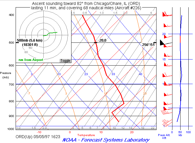 Figure 9
 Figure 10
 Figure 11